|
| Decyphering the location of Alfred the Great's fort in Hastings |
|---|
914AD Haestingeceastre at Baldslow Down
|
|---|
The Burghal Hidage fort recorded by Alfred the Great at Hastings in 914AD has never been located, but I
wish to show a logical possibility for this to be found on Baldslow Down next to the old Harrow playing fields
which is an area of Hastings.
From my place name research it would seem that places with dun, don or down in the name imply proximity to old
Celtic hill fort locations.
Baldslow can be translated from the Anglo Saxon (https://bosworthtoller.com):
Baels – ‘the fire of a funeral pile, in which dead bodies were burned’.
Hleów – ‘A shelter, protection, covering, refuge often applied to persons’.
Hence ‘Baldslow Down’ can be translated as the ‘fire refuge hillfort’ this is also possibly where
the current local ‘Firehills’ term derives from.
‘Harrow lane’ that runs alongside this location, and the name ‘Harrow playing fields’ can also be
derived from the Anglo Saxon (https://bosworthtoller.com):
Hár – ‘grey-haired with age, old’.
Hleów – ‘A shelter, protection, covering, refuge often applied to persons’.
Hence ‘Harrow’ can be translated into the ‘old refuge’ implying its age
|
Contents
|
|---|
|
|
What was the Burghal Hidage ▲
|
|---|
The Burghal Hidage(Wikipedia)
'is an Anglo-Saxon document providing a list of over thirty fortified places (burhs), the majority being in the
ancient Kingdom of Wessex, and the taxes (recorded as numbers of hides – an old measurement) assigned for their
maintenance'.
The document, so named by Frederic William Maitland in 1897AD, survives in two versions.
The list of these forts is shown in the table below:
| Burh location | Hidage | | Burh location | Hidage |
|---|
| Eorpeburnan | 324 | | Pilton | 360 |
| Hastings | 500 | | Watchet | 513 |
| Lewes | 1300 | | Axebridge | 400 |
| Burpham | 720 | | Lyng | 100 |
| Chichester | 1500 | | Langport | 600 |
| Portchester | 500 | | Bath | 1000 |
| Southampton | 150 | | Malmesbury | 1200 |
| Winchester | 2400 | | Cricklade | 1500 |
| Wilton | 1400 | | Oxford | 1400 |
| Chisbury | 700 | | Wallingford | 2400 |
| Shaftesbury | 700 | | Buckingham | 1600 |
| Twynam (Christchurch, Dorset) | 470 | | Sashes | 1000 |
| Wareham | 1600 | | Eashing | 600 |
| Bridport | 760 | | Southwark | 1800 |
| Exeter | 734 | | Worcester | 1200 |
| Halwell | 300 | | Warwick | 2400 |
| Lydford | 140 | | | |
|
Where are these Burhs(map) ▲
|
|---|
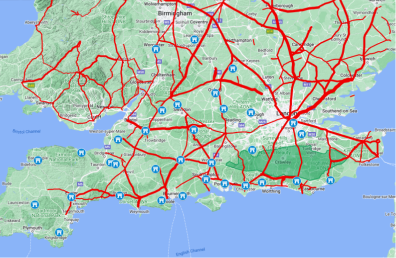
Map generated from Google My Maps
This is a map showing the locations of the Burhs as described in the Burghal Hidage and shows the approximate extent
of Wessex in 914AD, the green area north of Hastings shows the extent of the impassible Forest of Andredsweald, red
lines show Roman Roads.
|
Why are the names important ▲
|
|---|
If you look around Sussex, Hampshire and Dorset, a large number places ending in Don, Dun or Down are very close
to old hillforts, hence the possibility of this area being an old hillfort.
Hastings(Baldslow Down) – Baels Hleów Dun – the fire refuge hillfort
Langport(Burden Hill) – Burh Dun Hyll – The burh on the old hillfort
Hleów is now found in villages as low, lew or row, with a large number of the Burghal Hidage forts containing
these snippets which means refuge, such as:
Hastings(Baldslow Down) – Baels Hleów Dun – the fire refuge hillfort
Lewes – Hleów es – the river refuge
Axebridge(Callow Down) – Calu Hleów Dun – the open(bald) refuge hillfort
Lyng(Burrow Mump) – Burh Hleow Munt – The refuge fort on the mound
Eashing(Peper Harow) – Piþa Har Hleow – the old pith refuge
|
Can we work out the size of the Hastings Burh ▲
|
|---|
The fort at Hastings is shown as a size of 500 hides.
From the Burghal Hidage:
“For the maintenance and defence of an acre's area of wall 16 hides are required. If every hide is represented by 1
man, then every pole of wall can be manned by 4 men. Then for the maintenance of 20 poles of wall 80 hides are
required.”
A pole is an old measurement of length and is equal to 16 ½ft or 5.0292mtrs, however the Oxford English
Dictionary states that this unit, while usually of 16½ ft, may also be of 15, 18, 20, or 21 ft.
Therefore an approximate size of the fort using the 16 ½ ft length pole can be estimated.
From the information above, the Hastings Burh of 500 hides would have a wall of 125 poles long so about 2063ft (629
metres) of wall enclosing land of about 5.7 acres (2.3 hectares).
|
Differing Landscape 915AD ▲
|
|---|
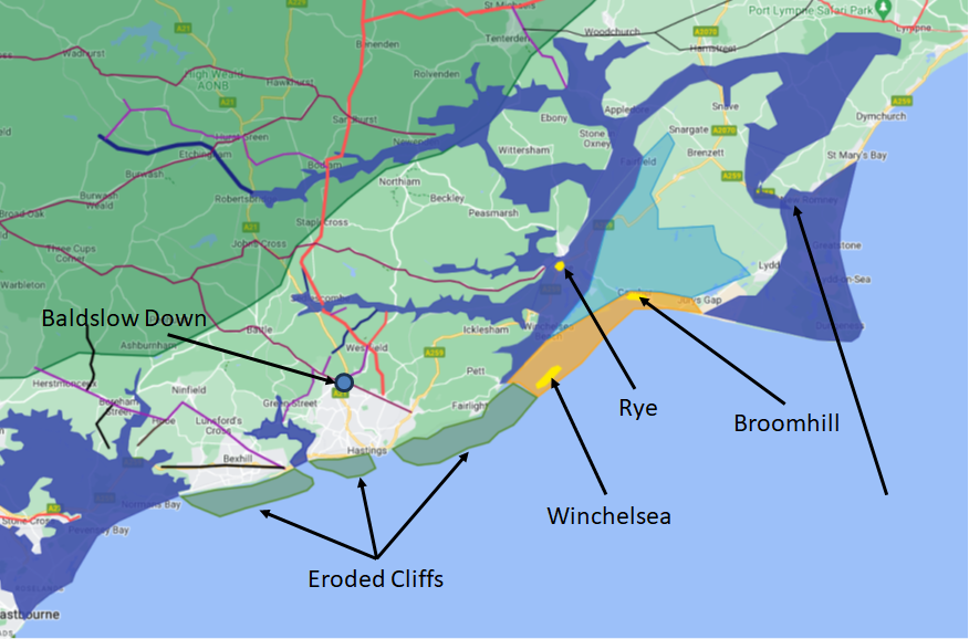
The landscape in the 900’s was significantly different from today.
The Eastern Sussex Rother which now reaches the sea at Rye Harbour joined the Brede and Tillingham rivers at Appledore
and in the 900's reached the sea at New Romney.
A severe storm in 1287AD threw shingle across the Romney Marshes which blocked the mouth of the Rother at New Romney and
it then found its current way to the sea at Rye Harbour.
The cliffs at Fairlight Cove are currently eroding at about 0.6 metre/year and would have, 1100 years ago been about 600
metres further into the Channel, the towns of Old Winchelsea and Broomhill would have been on shingle islands that would
have been surrounded by tidal salt marsh.
Rye would have been an island that only had access to the sea via Old/New Romney.
As you can see on the image, Baldslow Down is on very high ground, and overlooks the Brede Valley and the English
Channel. It is also on the old Ridgeway from Ore to Crowborough(maroon), has other Roman roads(red and purple) nearby.
|
Differing Landscape 915AD(map) ▲
|
|---|
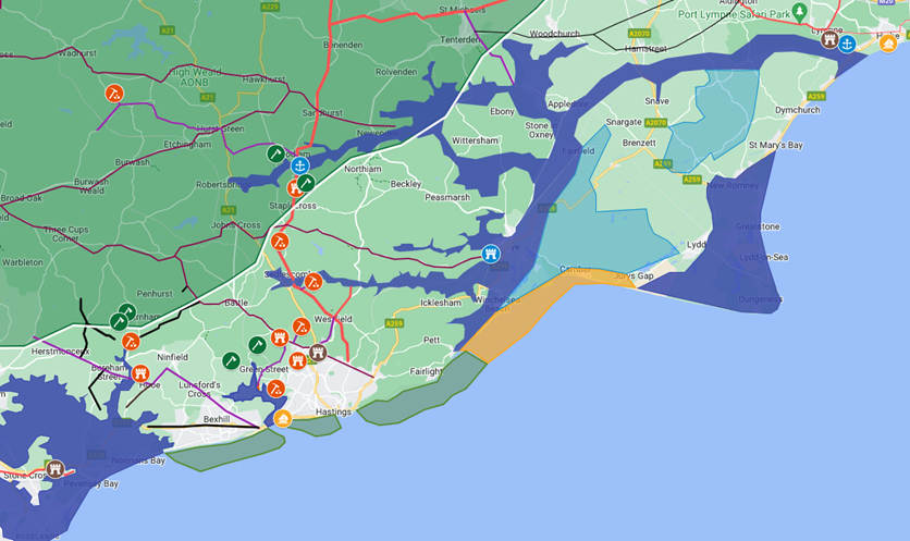
Map generated from Google My Maps
The extent of the sea is shown at 4.5 metres above modern high tide levels, please see our Sea levels at Pevensey
in early Saxon times for an analysis of this. The river Rother reaches the sea at Hythe, which was blocked in a
storm in 566AD with the Rother breaking through to create a new delta at Old Romney.
|
Differing Landscape(Roman) ▲
|
|---|
All the Burhs appear to be on hills with very good views across the sea, the high point at Baldslow Down gives excellent
views across to the Romney marsh and the entrance to the Brede/Rother which was at Old Romney at the time.
It also has excellent views towards the coast both from overlooking the Romney Marsh and the Channel. It also has good
views towards Telham where an old Roman castellum(watch tower) would have been located with views towards Pevensey and
the South Downs, and also to a second castellum at Castleham which would overlook the old Hastings harbour in the
Filsham valley.
In Roman times the whole area was an industrial zone mining and processing iron at Beauport park, and at Oaklands and
Footlands in Sedlescombe. A major 30ft wide road went from Gravesend through the forest of Andredsweald to Bodiam where
a Roman Port was located, then over the hill at Staplecross and across the Brede river to Westfield where it appears to
have joined another from a port in the Brede valley near the modern bridge up to Baldslow Down.
|
Differing Landscape (Roman map) ▲
|
|---|
Map generated from Google My Maps
Roman Industrial locations, iron production denoted by pickaxe symbol, woodworking/shipbuilding locations shown with
axes. The Rother reached the sea at modern Hythe, this changed after a significant storm in 566AD to reach the sea at
Old Romney.
|
Roman Iron and Timber export route(map) ▲
|
|---|
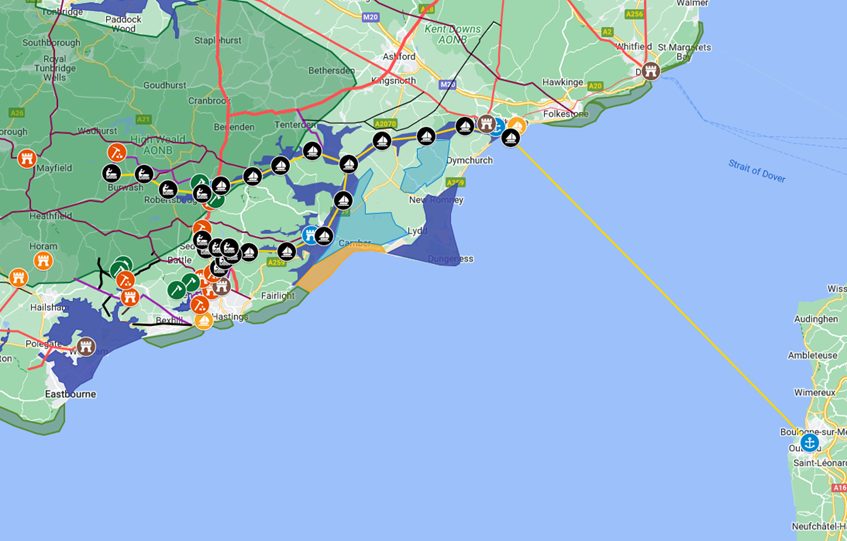
Map generated from Google My Maps
This map shows the export route for the unprocessed iron and timber being sent to Boulogne which was the headquarters of
the Roman navy in the channel, the Classis Britannica, where the iron was processed into weapons.
|
Historical suggestions ▲
|
|---|
Wikipedia definition of a hillfort is:
A hillfort is a type of earthwork used as a fortified refuge or defended settlement, located to exploit a rise in
elevation for defensive advantage.
The Romans probably took over an old Celtic hillfort at Baldslow Down in an area where the Celts were processing iron
(This iron may even have been the reason the Romans invaded Britain). This hillfort had an excellent view of the Brede
valley where a high percentage of the major Roman iron workings were located, and overlooked the major road from
Gravesend.
When the Romans left, the Saxon’s took over forming their own kingdom. The majority of village names are Saxon. If
Hastings had been settled by the Jutes from Kent it would have been spelt 'Hastinge' with the additional e.
The Saxons would have taken over the hillfort, and held it until 771AD when King Offa of Mercia took over the
independent Kingdom of Hastings. After the Battle of Ellendun
826AD Hastings was taken over by Wessex, hence the Burgal Hidage entry.
The most likely reason the Saxons took over the area was because of the proximity of the Forest of Andredsweald for oak,
iron for nails and shipbuilding, and the well trained shipbuilding and iron working population.
|
Location(old andnew map) ▲
|
|---|
Lets look at the detail of the area, from the early map we can see the limits of the suggested area, which is shown on
the Satellite view.
|
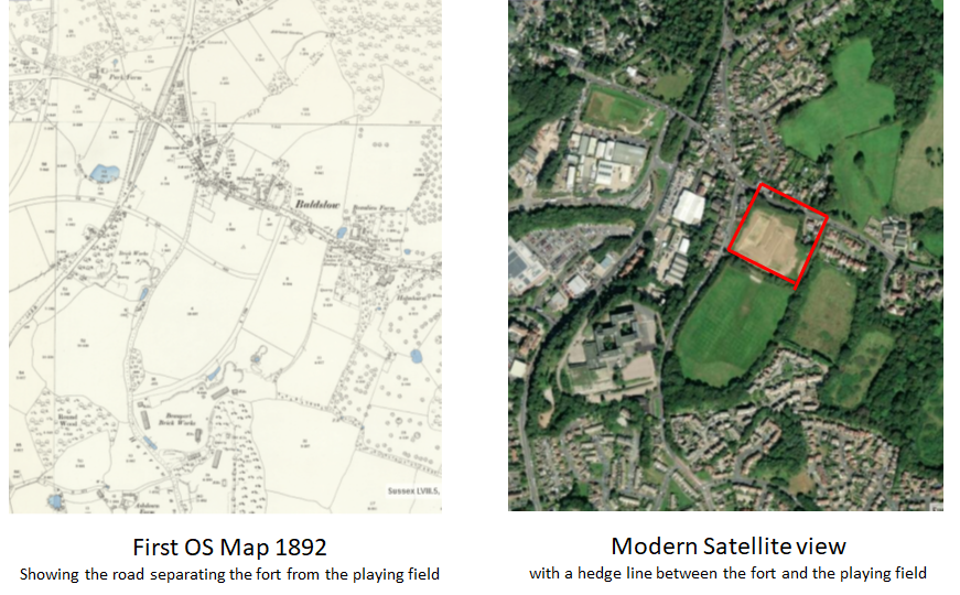
|
Location continued(satellite map) ▲
|
|---|
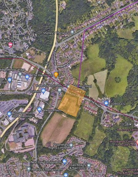
The purple line shows a suspected Roman road which joins the main Gravesend road to Baldslow, the magenta line shows the
ancient ridgeway from Fairlight to Crowborough where it joins the other north south Roman road to Lewes.
The area shown in orange has a 620 metre boundary and is a 2.3 hectare area, this is taken from Google My Maps.
This size fits the Hastings Burh size of 500 hides which would have a wall of 125 poles long so about 629 metres of wall
enclosing land of about 2.3 hectares – not a bad size if these estimates are valid.
|
Location continued(lidar map) ▲
|
|---|
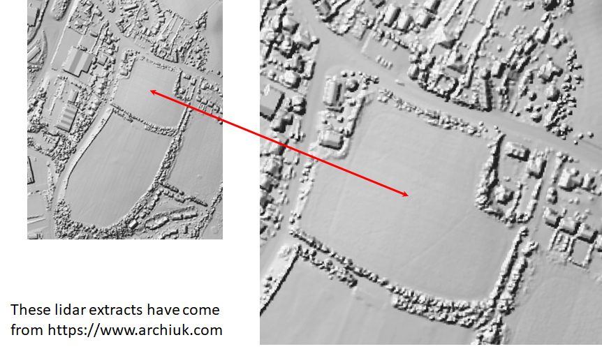
This is a lidar map(https://www.archiuk.com) showing the area, this was carried
out before the current development approval by the Council.
|
Conclusion ▲
|
|---|
I believe the details shown above make a persuasive argument for the Burghal Hidage Burh at Hastings
being located at Baldslow Down.
If this is the case then 146 years later in 1066AD the fort is most likely to still be in good condition and a good
defence, and might explain the phrase used in the Carmen de Triumpho Normannico - ‘You restore the forts that were
long since destroyed’ the forts being Hastings Burh and Pevensey Castle.
Pevensey was occupied by Earl Godwin in about 1050AD so was again probably in good order.
Master Wace reports:
‘The duke placed a guard in Hastings, from the best of his knights, so as to garrison the castle well.’ this
implies its an old castle and not the current stone built one overlooking the town that was constructed later.
He would also be unlikely to garrison the pre-packed forts constructed on landing as they would have been too small to
take knights, their horses and their associated serfs.
|